Publication: The Plan Journal 7 (2) 2022
Designers: Ian Caine, Gabriel Díaz Montemayor
Team: Trent Tunks, Joe Valadez, Tiffany Vargas
Date: 2022
The site for this new community prototype is the Rio Grande Valley, a transborder region in Texas USA that lies in the floodplain of the Rio Grande/Rio Bravo River adjacent to the Mexican State of Tamaulipas. The region is home to more than 2,000 colonias–informal, unincorporated settlements that flood regularly. Colonias typically lack civil infrastructure like sewer systems, paved roads, and potable water. In Texas, 400,000 people live in these settlements. Many are migrant workers from Northern Mexico who come for seasonal agricultural jobs.
The proposal leverages modular housing units which are standardized, prefabricated, packed, shipped, and assembled onsite. This project imagines a farming cooperative that extends modular efficiencies beyond housing to the entire site, unitizing the subdivision of land, utilities, flood control, and food production. The scenario rejects adversarial economic, social, and environmental arrangements associated with industrial farming, imagining more sympathetic relations between people, land, water, and capital.
The Modules:
Living Modules: Prefabricated SIPs enclosures provide infrastructure for the living, dining, cooking, and sleeping programs.
Farming Modules: Like traditional Mesoamerican chinampas, these artificial islands grow land, produce food, control flooding.
Foundation Modules: Hand-driven wood piers and beams elevate the entire community 3 feet above the 100-year flood level.
Water Modules: Stormwater is controlled via bioretention cells, which fill sequentially from west to east then release into a river.
Utility Modules: Site utilities including electrical, sanitary, and water are ganged and delivered to units via ducted chases.
Community Modules: This project imagines a dynamic and integrated relationship between people, water, land, and capital.
Publication: 2022 City of Weslaco Comprehensive Plan
Researchers: Ian Caine, Gabriel Díaz Montemayor, Bill Barker, Marcio Giacomoni, Albert Han, Esteban López Ochoa, Thomas Tunstall
Team: John Franklin, Francisco Gonzalez, Joe Valadez
Date: 2022
The City of Weslaco is a rapidly expanding community located in the Rio Grande Valley with a population of 42,000. Once part of a Spanish land grant known as Llano Grande, Weslaco was incorporated in 1921 and today exists as part of the Reynosa-McAllen metropolitan area, a transnational conurbation along the U.S.-Mexico border. This region, which lies adjacent to the Mexican State of Tamaulipas, is one of the fastest growing urban areas in the United States.
UTSA researchers worked with Weslaco residents and City officials to address the effects of rapid urban growth, specifically as it relates to issues of downtown revitalization, housing, parks, flood control, transportation, economic sustainability, and environmental resilience. Weslaco’s 2022 Comprehensive Plan specifically redefines the City of Weslaco’s growth calculus, expanding the community motto, “City on the Grow,” to include infill, redevelopment, and retrofit strategies. The process began in 2021 with three public charrettes that allowed residents to express their ideas, examine potential options, and help generate future growth scenarios that aligned decision-making with community values.
In July 2022 Weslaco City Commission unanimously approved UTSA’s update to the City’s Comprehensive Plan. The new document, which establishes a framework for community decision-making through the year 2045, represents sixteen months of collaboration between Weslaco city leaders, UTSA’s Center for Urban and Regional Planning Research (CURPR), and Gabriel Díaz Montemayor, Founding Partner of LABOR Studio.
Publication: Comfort Vision 2050
Researchers: Ian Caine, Bill Barker, William DuPont, Matthew Jackson, Corey Sparks, Tom Tunstall
Team: Diego Sanchez, Elizabeth Striedel, Ivan Ventura
Date: 2020
In 2015, 71% of Comfort residents voted against a proposition to incorporate their community, thereby affirming a deeply-held set of shared values that would come to provide a foundation for Comfort Vision 2050. First, the vote expressed the community’s unwavering commitment to property rights, understandable in a region historically composed of large-scale ranch owners. Second, the vote reflected a broad fiscal conservatism and aversion to new taxes. Third, the vote gave voice to a widespread, albeit passionately contested belief that in a community founded by German Freidenkers and abolitionists, individualized and decentralized decision-making was preferable to the creation of a centralized municipal authority. Finally, by rejecting incorporation, Comfort residents ensured that their community would remain aligned with the broader political status quo in the Texas Hill Country, where 90% of communities remain unincorporated (Hill Country Alliance, 2015).
These political realities make clear that a traditional vision plan, one that relies on central administration, could never succeed in Comfort. That’s why Comfort Vision 2050 offers a non-traditional, hybrid vision plan and action plan: The vision comes in the form of 30 Vision Statements that define the community’s stance on issues of the Environment, Infrastructure, Housing, Preservation, Economics, and Community. The action comes in the form of 75 Strategic Initiatives that county government, local non-profits, business leaders, and Comfort residents can pursue immediately and independently, without the benefit of municipal government.
Comfort Vision 2050 directly addresses the political dynamics of life in an unincorporated community by establishing a grassroots approach to urban planning that is decentralized, non-governmental, incremental, actionable, coordinated, measurable, and transparent. The plan specifically establishes a list of 75 Strategic Initiatives that are small-scale, diverse, and possible to achieve using grassroots action, without the benefit of city government.
Comfort Vision 2050 also offers a useful model for urban planning in the Texas Hill Country region, where 90% of the communities remain unincorporated (Hill Country Alliance, 2015). These communities need urban planning for all the same reasons that cities do: to prevent the fragmentation of local ecologies, protect local aquifers, maintain critical infrastructures, ensure access to housing, preserve physical and cultural history, attract and keep good jobs, expand critical services, facilitate civic discourse, and ensure timely decision-making.
The Comfort Area Foundation initiated this process, which was facilitated by the UTSA Center for Urban and Regional Planning Research in collaboration with the National Association for Latino Community Asset Builders, who contributed $25,000 from a U.S. Dept. of Housing and Urban Development grant.
International Competition: Dry Futures
Result: Honorable Mention (16 total selections/387 entries)
Jury: Allison Arieff, Charles Andersen, Colleen Tuite, Ian Quate, Geoff Managua, Hadley Arnold, Peter Arnold, Jay Famiglietti, Peter Zellner
Designers: Ian Caine, Derek Hoeferlin
Team: Emily Chen, Tiffin Thompson, Pablo Chavez
Date: 2015
Competition Brief
California – and much of the Western United States – is currently in the midst of a severe and unprecedented water crisis. After four consecutive years of exceptional drought, Governor Jerry Brown issued an executive order earlier this year intended to limit water usage and preserve the few resources that remain. But many worry that the measures amount to “too little, too late.” And the stakes couldn’t be higher: not only is California the most populous state in the country, it is by far the largest agricultural producer. Built on centuries of questionable riparian practices and infrastructure, this agro-industrial behemoth not only consumes the majority of the state’s dwindling water reserves, but amounts to a significant chunk of the national and international economy.
WATER MAY VERY WELL END UP BEING THE DETERMINING ISSUE OF THE NEXT CENTURY.
According to many experts, the drought in California correlates to both unsustainable human practices and the larger product of unsustainable human activity: climate change. It is simply irresponsible to imagine that a solution will magically appear off the coasts or in the clouds or anywhere else. California is on the verge of collapse. And for millions around the world – from Syria to Brazil – drought is already a determining factor in everyday life, creating conflict and reorganizing social relations.
While the practice of architecture may have not traditionally taken the primary role in determining how water is used, today, we no longer have a choice. Water is not only a fundamental precondition for dwelling, but the manner in which we choose to build (or not) is pivotal to the future viability of entire regions of the world. Water may very well end up being the determining issue of the next century. Yet, increasingly, it feels that the discourse of the “smart city” has overtaken all considerations of the future of architecture. How will ecological crises and technological advancement cohabitate the same future?
Archinect is launching a new competition oriented around the unfolding drought crisis in California. We believe architects possess a remarkable set of tools and skills that uniquely establish the capacity to adapt to a problem that is both multifaceted and enormous. We are looking for the imaginative, the pragmatic, the idealist, and the dystopian.
Competition Submission
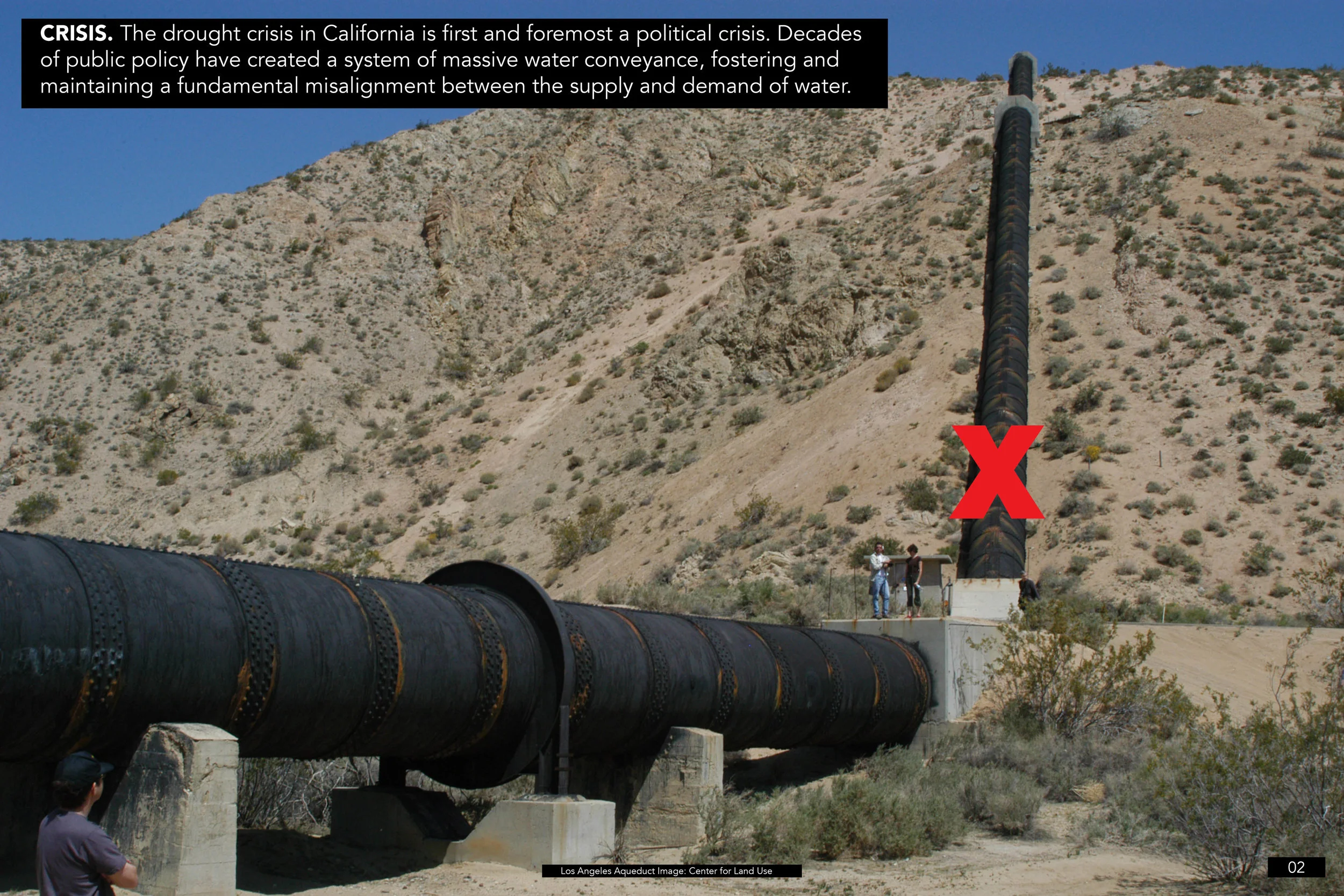
The drought crisis in California is first and foremost a political crisis. Decades of public policy have created a system of massive water conveyance, fostering and maintaining a fundamental misalignment between the supply and demand of water. The untenable status quo in California is maintained through an elaborate slew of public policies, designed to support a system of water-trading between western states in areas like the Colorado River Basin.
The Continental Compact proposes to fundamentally alter the culture of water-trading: re-legislating water distribution, first in California and ultimately throughout the United States, Canada and Mexico. The new laws will be based on four principles: Don’t transfer water. Do guide population growth to water. Do allow regions to shrink by attrition. Do return the river to its natural course.
California has maintained itself through an elaborate mechanism of water conveyance via aqueducts for decades. Unfortunately, the financial and environmental costs of this strategy are high. Currently the financial costs are being borne by the State and Federal governments, while the environmental costs are simply externalized, thereby delaying and intensifying their impact. This is an infrastructural shell game that California cannot win.
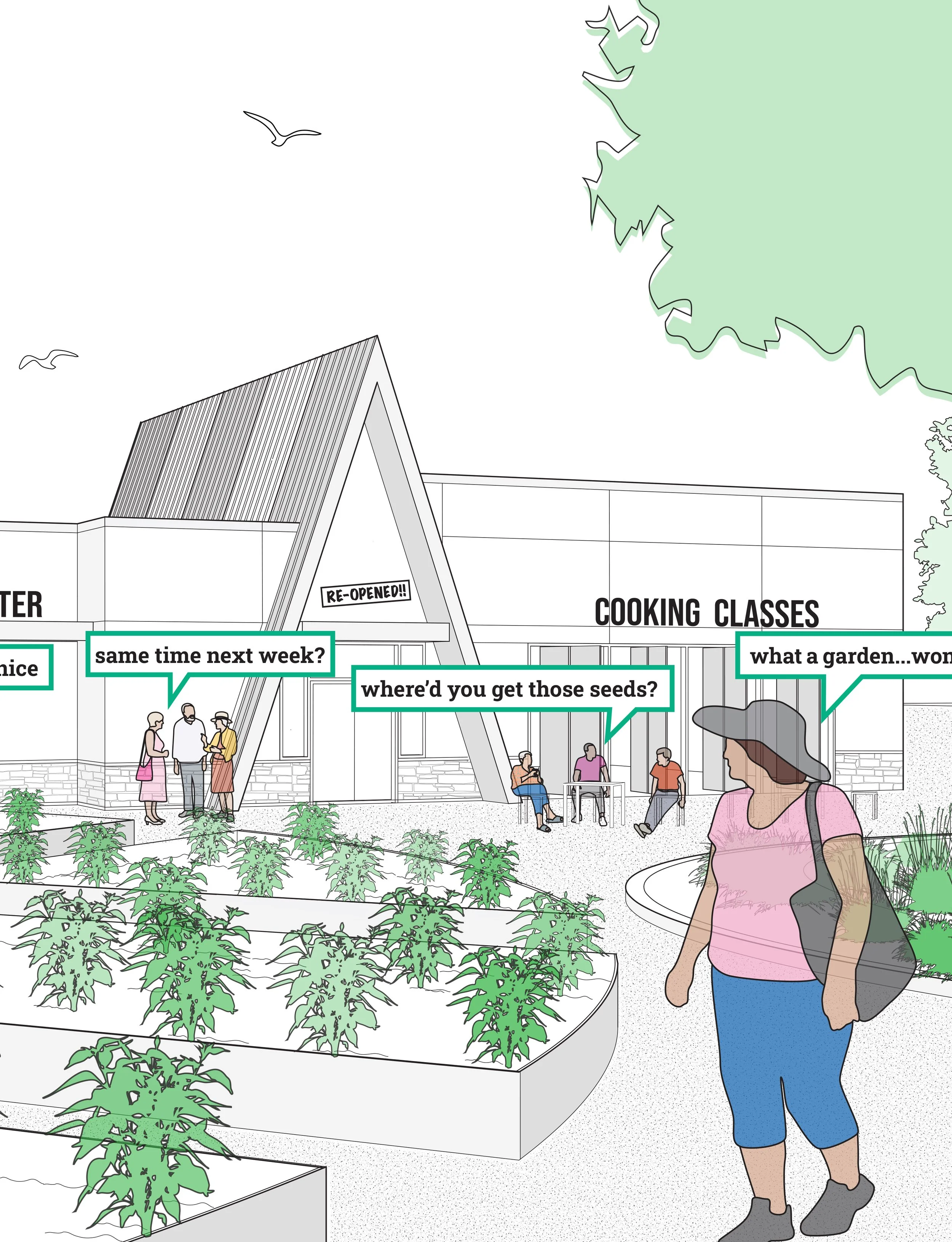
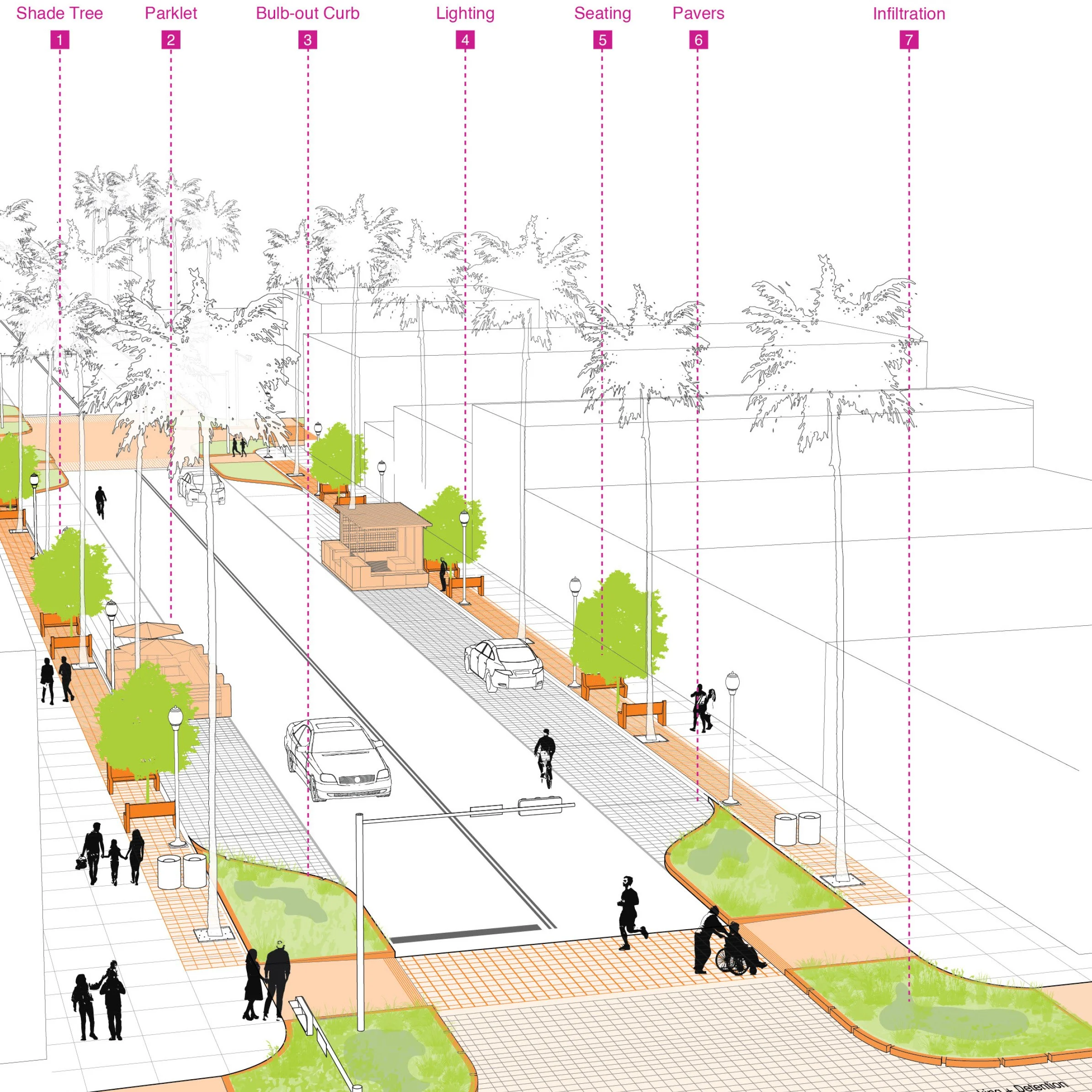
The Continental Compact provides a long-term solution to the contradiction that is California, incentivizing urbanism in water-rich basins near dams, rivers and deltas. The 3 types of hydro-urbanisms leverage existing water resources to create a conurbation at the scale of the river basin. Locally, each responds to the specific characteristics of its riverine, geographic and landscape environment. The hydro-urbanisms are capable of accommodating diverse programs including agriculture, residential, ecology, industry, recreation and tourism.
The Continental Compact replaces hydraulic urbanism with hydrological urbanism. Simply put, the Continental Compact stops moving water to the people and starts moving people to the water. The Continental Compact incentivizes a series of Hydro-regions, each leveraging a piece of new infrastructure in an existing water basin. The resulting megalopolis allows new water-rich urbanism to grow over a period of one hundred years. Conversely, it allows existing water-poor urbanism in Los Angeles, San Diego, San Francisco, Phoenix, and Denver to slowly shrink via attrition. The positive environmental and financial benefits of the revised policy will be significant, saving energy, reducing carbon emissions, slowing subsidence, lowering infrastructure costs, and regenerating California’s deltas.
The history of Westward Expansion in the United States was an epic success, leveraging cheap land and abundant natural resources to grow the country. Things are very different today: land is expensive, resources are scarce, and state and federal governments are increasingly unable to afford the spiraling price tag associated with infrastructural obligations.
Current 2050 growth projections in the U.S. don’t factor what will likely become the most critical determinant of successful urbanism: water supply. The Continental Compact re-directs growth from Mega-regions to Hydro-regions, investing in water-rich urban conurbations built around dams, rivers and deltas. The Compact re-invests the massive resources that currently support the construction and operation of aqueducts into the construction of new infrastructure to support water-rich sustainable urbanism.
Images: Architect (cover), remainder of images by Ian Caine and Derek Hoeferlin
Publication: Lunch 12: Tactics (University of Virginia)
Designers: Ian Caine, Curtis Roth, Rients Dijkstra (faculty critic)
Date: 2018
excerpt 1:
0. The Story of the Post-Storage City is a speculative design project that considers the tactical potential of severe constraint. The production of material goods has driven the economic, spatial and programmatic development of cities in the developed world since the advent of the Industrial Revolution. This project imagines a post-consumer city where the impact of material goods is dramatically reduced through the tactical removal of a critical consumer apparatus: Storage. The Story of the Post-Storage City envisions a world where closets, attics, garages and even streets become obsolete. It is a meditation on the prominence of tactical mechanisms in design. The project imagines that by altering a simple apparatus like Storage, it is possible to initiate a series of tactical responses that fundamentally transform the form of the city. The Story of the Post-Storage City suggests that the next urban revolution will emerge not from centralized planning, but rather from an accumulation of tactical decisions by individuals motivated by self-interest and severe ecological demands. The Story of the Post-Storage City imagines that by eliminating Storage, society can halt expansion into suburban and exurban landscapes, conjuring the possibility for a series of radically new urban configurations.
1. In the second decade of the twenty-first century, an unprecedented glut in crude oil prices led to skyrocketing levels of personal consumption and carbon emissions. In a desperate attempt to avert ecological disaster and maintain a semblance of global order, the United Nations introduced the Resource Scarcity Act of 2020. The authors of RSA 2020, as it became known, decided that the best way to curb soaring levels of personal consumption in the Developed World was to implement a single but severe restriction on the one thing that made consumer culture possible: Storage. The U.N. correctly predicted that limiting Storage would create a de facto tax on consumption, thereby forcing markets to generate a post-petroleum consumer economy. The mandate was simple but sent shock waves around the globe. The legislation consisted of just one sentence: The Resource Scarcity Act 2020 requires that everyone store all of their stuff in a U.N. registered Cube© equal in size to a 2012 Honda Accord.
2. This is the story of the Post-Storage City. It all began in 2020, a year that famed astrologer and newspaper columnist Jeane Dixon once claimed would witness Armageddon, but instead marked the death of consumer culture in the Developed World. The end came in the form of a fleet of white trucks that left manufacturing plants across the globe to deliver a seemingly endless supply of pristine white Cubes© to consumers in Singapore, Cincinnati and Sydney alike. Befuddled citizens, many who assumed that Cube© Day was a Y2k-like myth awoke to an alien landscape littered with plastic cubes. Twitter crashed with the hashtag “#WTF?” as distribution teams deposited the Cubes©, each 500 cubic feet in volume, onto front lawns, alleys and driveways around the world. Each Cube© came with a set of instructions from the U.N. As families gathered to read over the details of RSA 2020, they realized that the new restrictions on Storage would change their lives forever. By the time that the dust settled, lifestyles had shifted, economies distorted and cities transformed.
excerpt 2:
10. It didn’t take long for the form of the Post-Storage City to come into focus: The Hub-and-Spoke model of the traditional city gave way to a polycentric field of connected transit and distribution nodes. The space in between these nodes didn’t change much as people continued to use their car for trips to school, work and home. On Saturdays, however, Car Owners left their cars in the Cube© and made extended visits to catch up with friends who lived in the walkable nodes. As cities consolidated around new Distribution and existing Transportation nodes, expansion into the suburban and exurban landscape ended. Cities could no longer be described with a single image--the skyline panorama--but instead gained distinction through a diverse mixture of block configurations, Distribution Clusters, and transportation networks. Ultimately, the Post-Storage City of 2050 did not arise from a centralized planning process. Instead, it resulted from the accumulation of individual decisions, coordinated primarily by Home Owners at the scale of the lot and the block. Just as Otis’ elevator gave rise to the skyscraper, and Ford’s Model T fueled growth in the post-war American suburb; UN Secretary-General Ban Ki-moon’s single white Cube© sent shock waves across consumer landscapes across the globe, changing the way that people stored their stuff, and ultimately, the way that they lived their lives.
Images: University of Virginia School of Architecture (cover), remainder of images by Ian Caine and Curtis Roth
Team: Ian Caine, Curtis Roth, Rients Dijkstra (faculty critic)
Date: 2011
It is known that city form results from advances in science and technology and evolutions in economic systems, at least as much as from other forms of cultural input. There is convincing literature that describes the history of warfare as an outcome of the history of technological advance. Just the same, the history of cities, of urban development, of planning, can be told along the lines of technical advancement.
(Cities in civilization, Peter Hall, 1998)
To illustrate the point: there is a famous example, taken from Delirious New York, where Koolhaas describes how the skyscraper concept resulted from the marriage of innovation in steel manufacturing technology and the invention of he elevator. (To be more precise, it was the invention, by Elisha Graves Otis, of the fail safe device that prevents elevators from falling if the cable snaps.) Imagine how without the elevator brake, high urban density could not have come into being. Manhattan would have been impossible in its current form; high-rise down towns would take up 10 to 20 times their current surface area.
I am telling you this to make one thing clear. A change, a small change even, in the elements that constitute the machinery that is the city, can have a big impact on the future form of the city, its esthetic appeal and its sustainability. These changes can be large and structural, impacting the future layout and the development of urban form, or they can be small and ubiquitous, changing the streetscape and the ways people live. My proposal is to study storage.
-Rients Dijkstra, 2011
Images: Ian Caine and Curtis Roth
International Competition: Rising Tides
Result: First Place Winner (1 of 6 winners/131 entries)
Jury: Michael Sorkin, Walter Hood, Denise Reed, Marcel Stive, Tracy Metz
Team: Ian Caine (Designer), Derek Hoeferlin (Designer), Michael Heller (Research + Illustration)
Date: 2009
1. This Proposal Re-Situates the Problem of Rising Tides within a Larger Water Crisis.
Rising tides are not the most significant outcome of climate change. They are merely one symptom of a more daunting water crisis. The threat of rising tides can provide a catalyst which leads us to comprehensively re-balance the water system in California and beyond.
2. We Propose a New Set of Organizing Principles to Manage Water.
Re-Localize. We propose to re-conceive water distribution as a localized concern, allowing real issues such as topography, water supply and demand, and the maintenance of local watersheds to dictate policy.
This thinking would have far-reaching policy impacts, including stopping the massive transport of water to southern California. This might ultimately impact demographic patterns.
As the transport of water decreases, localities such as L.A. and San Diego will be forced to confront their own issues of supply and demand.
Re-plenish. We propose a controlled re-flooding of The Sacramento-San Joaquin River Delta to re-constitute ecological diversity and re-balance fresh and salt water levels. This would involve redirecting existing aqueducts to flood the Delta.
The X2 line, which represents the separation between fresh water and salt water in the Delta, shifts depending on the amount of water that California exports to aqueducts. This balance is integral to the maintenance of a diverse estuary habitat.
Re-power. We propose tidal power as a new energy source to power desalination plants. This means investing in turbine in high current areas and tidal pools in areas with sensitive natural habitats.
We will also export excess power to the electrical grid to save associated energy costs by eliminating water transport.
Re-grow. We propose to re-generate tidal marshes to create storm barriers, restore crucial ecology, and increase local carbon sinks.
3. This is a Policy Proposal, Not an Architectural Solution.
Our proposal is political first and foremost. We purposefully avoid specific physical solutions, instead emphasizing goals and desired outcomes. This proposal involves expanding the architect’s role from designer to long-range policy advocate. This is a 100 year plan, as ecology does not correspond to election and market cycles.
4. We Propose a Policy-based Toolkit.
We advocate for an ambitious policy-based toolkit that trades the “watershed hopping” method of massive water transport, which is energy intensive and environmentally destructive, for a more localized approach.
Images: Bay Conservation and Development Commission, Ian Caine and Derek Hoeferlin, Ian Caine and Derek Hoeferlin, Ian Caine and Derek Hoeferlin, The Discovery Channel
Publication: Arqa 108
Designer: Ian Caine
Team: Christopher Hernandez, Gilbert Pena
Date: 2013
This design research examines the cycle of growth and decline associated with Walmart Supercenters as a way to reconsider the transformation of exurban territories in the United States. The project contends that many of the negative externalities associated with big box developments result from the difference between the financial lifecycles of buildings and infrastructure. The project seeks to re-align these lifecycles.
Since the first Walmart Supercenter opened its doors in 1988, the big box typology has emerged as the primary form of commercial development in North America [1]. In the U.S. today, the ten largest retailers are all big box developers [2]. Wal-mart’s extraordinary economic expansion is leading to previously unseen geographic expansion, fundamentally altering the physical form and scale of the U.S. landscape. With 4,663 domestic stores and counting, today Wal-mart Stores, Inc. may be the most important generator of urban form in the U.S. [3]. Sound crazy? Consider that the total floor area of Wal-mart retail locations in the U.S. is now larger than the footprint of Manhattan [4].
It is difficult to talk about urban transformation in the U.S. without first addressing the issue of land speculation. For it is land speculation, above all else, that has historically driven development in the exaggerated capitalist landscape of the U.S. Not surprisingly, two of the most ambitious attempts to guide the country’s development are associated with efforts to minimize the negative externalities associated with real estate exchange: The Land Ordinance of 1785 and The Commissioner’s Plan of 1811 for Manhattan.
The Land Ordinance enabled the rectangular survey of the U.S., which rationalized a market that might otherwise have been plagued by leftover lots and awkward adjacencies. In this regard, the successful history of land speculation in the U.S. is due in no small part to the geometric regularity and predictability that emerged from the rectangular survey. Likewise, the Commissioner’s Plan of 1811 for Manhattan utilized the power of geometry to tame the uncertainties of a fickle real estate market. The introduction of the grid further revolutionized the legal and conceptual understanding of land in Manhattan, re-casting it as real estate: a commodity that could be bought, sold and re-packaged for economic gain [5].
In 2013, exurban communities in the U.S. would clearly benefit from a re-commitment to geometric regularity and economic predictability. Many of the negative externalities associated with uncoordinated commercial big box developments--underutilized and vacant structures, redundant parking, and ineffective storm water management, for example--can be attributed to uncoordinated speculation and a fundamental mismatch between the financial lifecycles of buildings and the surrounding urban landscape.
The ChangeScapes project intervenes in the typical development sequence of a greenfield Walmart Supercenter, leveraging the inevitable growth to achieve a more balanced relationship between public and private interests. The project re-conceives of parking, storm water, and circulation infrastructure as a public commodity; to be designed, built, and managed by the local municipality.
Big box developments and their surrounds accommodate a wide array of activities throughout the year. Some of these activities are cyclical in nature: a Saturday afternoon farmer’s market during the summer months, for instance. Other programs are less amenable to change: housing is a good example of a program that doesn’t transform easily. The proposal aims to re-align these lifecycles by accommodating the divergent change increments required by various programs.
While the ChangeScapes scenario is highly orchestrated at the micro-scale, it does not involve active planning at the macro-scale. The territorial form of this landscape is therefore given over to multi-nodal and uncoordinated patterns of development. This situation reflects the fragmented local political structure that persists in the U.S.—a condition that renders synchronized regional planning virtually impossible. For better or worse, the development of exurban landscapes in such places will continue to emerge from the highly idiosyncratic process of land speculation as practiced by mega-developers like Wal-mart Stores Inc.
This project does not suggest that designers and planners should abandon urban processes to economic requirements and capital markets; rather, it seeks to empower decision-makers by giving them the tools to critically and proactively engage the change processes that drive the growth associated with big box development. Increasingly, the management of urban processes appears to offer the best opportunity to strategically impact development in exurban territories. With this in mind, the project makes the claim that contemporary urbanism isn’t the design of form: it’s the design of change.
Notes
[1] History Timeline. (2013). Retrieved February 5, 2013 from http://corporate.walmart.com/our-story/heritage/history-timeline.
[2]2011 Top 100 Retailers. (2012). Retrieved May 5, 2012 from http://www.stores.org/2011/Top-100-Retailers.
[3]Our Locations. (2013). Retrieved June 16, 2013 from http://corporate.walmart.com/our-story/locations#/united-states.
[4]LeCavalier, J. (2012). All those numbers: logistics, territory and walmart. Places, Retrieved March 15, 2012 from http://places.designobserver.com/feature/walmart-logistics/13598.
[5] Ballon, H. (Ed.). (2012). The greatest grid: the master plan of manhattan 1811-2011. New York: Museum of the City of New York & Columbia University Press.
Images: arqa arquitetura e arte (cover), remaining images by Ian Caine.
International Competition: Build-A-Better-Burb
Result: Finalist (23 finalists/212 entries)
Jury: Allison Arieff, Teddy Cruz, Daniel D’Oca, Rob Lane, Paul Lukez, Lee Sobel, Galina Tachieva, Georgeen Theodore, June Williamson
Designers: Ian Caine, Derek Hoeferlin
Team: Jing Chen, Xi Chen, Akshita Sivakumar, Jonathan Stitelman
Date: 2010
The 21c Right-of-Way (R.O.W.)
21c R.O.W. is radical but real. It is a new suburban concept that will fundamentally alter the physical and legal structure of the strip.
The 21c R.O.W. does not require any new technology. It begins with the assumption that we cannot ‘invent’ a solution for our suburban predicament.
21c R.O.W. requires collective thought and action. It is implemented locally through the introduction of a new, coordinated municipal zoning structure.
21c R.O.W. balances public and private interests. It repositions the public sector as the long term guardian of infrastructure and public space, while freeing up the private sector to do what it does best: innovate and money-make.
Definition
The 21c R.O.W. expands the existing singular public right-of-way through private lots to create efficient parking, multiple access and comprehensive water management. In order to minimize the impact on developers, this right-of-way will track along existing demising lot lines--essentially acting as a thickened easement. Developers, in return for giving up this underutilized land, will receive full access to this new public infrastructure.
Clustered Lots = Efficient Lots
One of the best ways to retrofit thousands of acres of underutilized asphalt is to decrease the real estate devoted to parking and redundant infrastructure. In order to decrease the total amount of infrastructure on the strip, we propose to “cluster” adjacent parcels, thereby allowing them to share critical infrastructures including parking, pedestrian, bicycle and water management.
Individual Parking=Redundant Parking
Even the relatively conservative standards of the Urban Land Institute suggest that the Smithtown cluster case study has too much parking. The insertion of the 21c R.O.W. will allow Smithtown and other Long Island downtowns to consolidate parking.
Individual Access=Redundant Access
The insertion of the 21c R.O.W. will allow Smithtown to consolidate and expand access for pedestrians and bicyclists while reducing the number of car trips. Comprehensive on-site water management will retain and delay water before it reaches the storm sewer.
Juried Exhibition: Museum of Contemporary Canadian Art (MOCCA) To-Be-Destroyed Exhibition, Toronto, CA
Designer: Ian Caine
Team: Raul Montalvo
Date: 2014
Traditional museums gather, reduce, and preserve culture; more recently they commodify, franchise, and export culture. Living Galleries offer an alternative model: one that recognizes culture as a dynamic, place-based phenomenon that resists simplification. Living Galleries reside not in museums but rather in the city itself. Diverse publics generate, curate, consume, and critique gallery content. This process privileges diversity over clarity, democracy over authority. Content and media in Living Galleries remain fluid: art, propaganda, politics, commerce, music, ecology, work, images, apps, songs, maps, and movies all remain in play. Living Galleries guarantee that culture, like life, remains a work in progress.
Images: Museum of Contemporary Canadian Art (Cover), Ian Caine and Raul Montalvo
Publication: ACSA 101 National Conference Proceedings: New Constellations/New Ecologies
Designer: Ian Caine
Session Chair: Alan Berger
Date: 2013
excerpt 1:
Abstract
In 1950 Sam Walton opened a discount variety store in Bentonville, Arkansas called Walton’s 5-10 and set into motion a chain of events that would revolutionize the scale and character of retail development in North America. In the subsequent decades Wal-Mart Stores Inc. would systematically reinvent every component of the big box equation, from the size of the buildings to the financing of civil infrastructure.
This paper focuses on a critical and unintended consequence of the transformation: the multiplication of material waste. The waste associated with big box developments manifests in numerous forms: abandoned buildings, underutilized sites, redundant water and parking infrastructures. The project outlines eight design interventions—the Big Box Operations—to manage waste and change in Walmart Superstores. The Big Box Operations rest on three assertions: first, that much of the excess associated with big box developments results from the difference between the material life-cycle of the built landscape and the financial life-cycle of the big box structure; second, that in order to align these time frames, developers and municipalities must re-conceptualize building systems as dynamic processes that are transitional, not permanent, in nature; and third, that to achieve this shift, these two critical actors must fundamentally reinvent their economic and political relationship.
The site for this design research is the Walmart Home Office and Superstore in Bentonville, Arkansas—center of the Walmart universe. This project re-imagines the legal right-of-way on Sam Walton Boulevard as an expanded physical and legal armature, one capable of streamlining redundant infrastructures and managing the material excess that results from uncoordinated private development. The paper ultimately contends that municipalities, by bringing the design of civil infrastructure back into the public fold, can leverage capital investment patterns to reduce waste and manage the change associated with Walmart urbanism.
excerpt 2:
Imagining A Secondary Transformation
This project recommends that the best response to Walmart urbanism and the accompanying cycle of waste is a secondary transformation, one with equally radical implications.
This proposal seeks to bring the civil infrastructure of suburbia into line with the logic of Walmart urbanism. It re-imagines the space surrounding Walmart big boxes as a legally public landscape; one that introduces an expanded right-of-way in an attempt to strike a more productive balance between development and infrastructure, between commerce and government.
The goal is not to condemn or censure the retail giant, but rather to leverage its enormous growth potential for public gain; protecting the City of Bentonville and places like it from the negative externalities associated with retail development while further liberating Walmart to do what it does best: money-make.
excerpt 3:
The Big Box Operations
1. Implement a Grid.
2. Expand the Legal Right-of-Way
3. Rationalize the Lots
4. Coordinate Services
5. Guarantee Passage
6. Insert Program
7. Consolidate Parking
8. Slow the Water
Images: The Association of Collegiate Schools of Architecture (cover), remainder of the images by Ian Caine